Kun Zhang1 , Haibin Song1,* , Linghan Meng1 , and Shun Yang1
1State Key Laboratory of Marine Geology, School of Ocean and Earth Science, Tongji University, Shanghai, China
*Corresponding author.
E-mail address: hbsong@tongji.edu.cn (H. Song).
Abstract
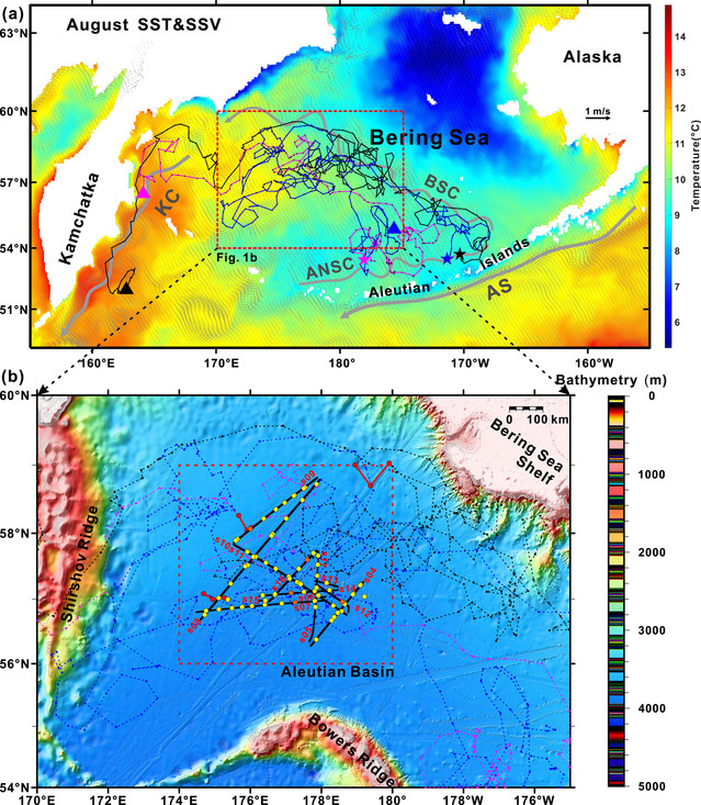
Subsurface eddies, characterized by their cores located within or below the pycnocline, cantransport materials over long distances in the ocean's interior. Observations of these eddies are sparse, limitingour understanding of their regional distribution and detailed horizontal structures, particularly in high‐latitudeareas. The Bering Sea, situated in the subarctic region, is among the world's most productive areas andsignificantly influences the Arctic Ocean's state, thereby impacting climate change. In this study, we utilizeultrahigh resolution (approximately 10 m) data to investigate the distribution and characteristics of subsurfaceeddies in the Aleutian Basin, Bering Sea. We detected 44 subsurface eddies in 13 survey transects and analyzedtheir morphological and hydrographic characteristics, spatial distribution, propagation, and transport. Theresults show that the average core radius of the subsurface eddies is about 11.62 km and they exhibit complexstructures in both the core and flank regions. The dichothermal layer cold‐core eddies are prevalent in the deep‐water region of the Bering Sea, contributing approximately 1.76 Sv poleward and westward transport in thesubsurface layer. This is the first three‐dimensional depiction of subsurface eddies in the Bering Sea, revealingthat the prevalence of subsurface eddies in the Bering Sea may have been negligent, with significantimplications for the hydrographic and biogeochemical properties of both the Bering Sea and the Arctic Ocean.More detailed comprehensive and long‐term observations should be made to assess the global impact ofsubsurface eddies in the future.
Full article: https://doi.org/10.1029/2024JC021402

Fig. (a) Distribution of sea surface temperature (SST) and sea surface current velocity (SSV) in the Bering Sea during August 2011. (b) Distribution of survey lines and hydrographic stations in the Aleutian Basin.


