Chang Liu 1*, Bojing Zhu2, and Yaolin Shi3
1 State Key Laboratory of Marine Geology, Tongji University, Shanghai, China
2 Yunnan observatories, Chinese Academy of Sciences, Kunming, China
3 Key Laboratory of Computational Geodynamics, Chinese Academy of Sciences, Beijing, China
Abstract:
There are two seismic gaps in the southwestern section of the Longmen Shan Fault (LMSF): (1) the gap amid the ruptures of the 2008 Wenchuan and 2013 Lushan earthquakes and (2) the gap in the southwestern-most section of the LMSF. Conflicting explanations have previously been proposed to estimate the hazards associated with these seismic gaps. In this study, we used a complete earthquake (M≥6.0) catalogue for the past 300 years to re-evaluate the seismic hazards by calculating the change in the Coulomb stress caused by nearby large earthquakes. When combined with the inter-seismic tectonic stress loading process, our results suggest that there is a high possibility of a future earthquake in seismic gap 1 because of the enhanced stress caused by the 2008 Wenchuan and 2013 Lushan earthquakes, although the 1970 Dayi earthquake (Ms 6.2) did rupture the center of the gap. However, the risk of an earthquake occurring in seismic gap 2 has decreased due to the unloading stress triggered by 14 large historical earthquakes on the Xianshui He Fault. This indicates that the seismic hazards of the two gaps differ even though they are less than 35 km apart. These findings differ from the results of previous studies, which were obtained using earthquake-induced stress modeling, inter-seismic stress modeling, estimates of earthquake moment accumulation and release, and paleoearthquake analysis. Our research sheds new insights on seismic hazard estimates for the southwestern LMSF, and might be helpful in determining the disaster relief distribution in Sichuan province, China.
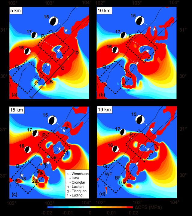
Figure 1: Map the ΔCFS of the southwestern LMSF at the depth (a) 5 km, (b) 10km (c) 15 km, and (d) 19 km induced by the 17 major historical events on the LMSF and the XSHF. The white stars denote the epicenters of the 1970 Dayi, 2008 Wenchuan, 2013 Lushan earthquakes, 1327 Tianquan earthquake, and 1941 Luding-Tianquanearthquakes. The characters f-k indicate the following cities: Luding, Tianquan, Lushan, Qionglai, Dayi and Wenchuan, respectively.
Full Article:https://agupubs.onlinelibrary.wiley.com/doi/full/10.1029/2019JB018160